

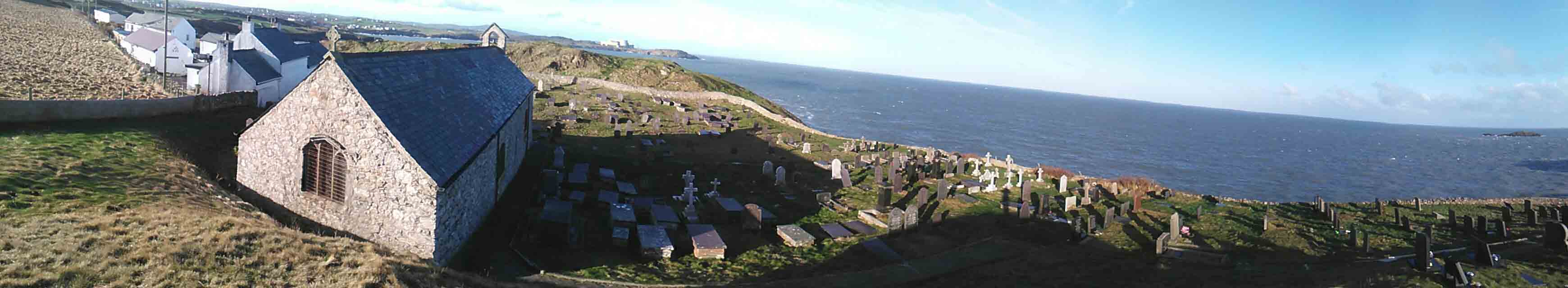
Some churchyards interact with their landscape in the most striking of ways, especially those in dramatic coastal locations. While perhaps St Patrick’s chapel, Heysham, St Materiana’s Tintagel, and Whitby are the most famous British coastal churchyards of early medieval origins, St Patrick’s Llanbadrig stands apart in my recent experience. I visited on a freezing cold January morning in bright sunlight. The church and its churchyard are just east of Cemaes, situated in a startlingly precipitous location above cliffs, on a headland on the northern coast of Anglesey. There are very few early medieval churches in such beautiful positions, and with the added benefit of a nuclear power station on the horizon too!
 Sadly, the church was closed and I couldn’t get to see inside. Within is an early Christian inscribed stone – a square-sectioned pillar with a cruciform shaped incised head created by two interlocaking interlace loops within a circle. Below the circle is a vertical line with two side-arms created by horizontal loops. This stone – AN10 – constitutes the earliest and only evidence of an early medieval burial/religious site at this location. Situated within the church and standing at the west end, it has been dated by Nancy Edwards to the 10th-12th centuries AD. I hope to go back between May and Sept when it promises to be open 10am-12pm and 2pm-4pm.
The church fabric is medieval, although it was much restored in 1884 by Henry Stanley, 3rd Baron Stanley of Alderley; incidentally he was the first Muslim member of the House of Lords (from 1869); he was a restorer of multiple churches on Anglesey. It was clearly under his instruction that the early medieval stone was displayed prominently in the church following its restoration. Is this the only early medieval inscribed stone from Wales put on display under the direction of a Muslim?
The church dedication to St Patrick is linked to a legend that the famous 5th-century saint was wrecked on Ynys Badrig and taking efuge in a cave there (Ogof Badrig), taking water from a well close by (Fynnon Badrig). The early stone and combination of toponymic associations with Patrick suggest strongly this is an early medieval ecclesiastical site.

Denied entry to the church, I instead briefly explored how the churchyard adapted to the restrictive topography. Beside the porch are a pair of the earliest gravestones, displayed in a prominent position, one dating to the late 17th century, one to the early 19th century. They serve a role as ‘ancestral’ monuments for the community’s dead: proudly displayed framing the entrance for all visitors, including parishioners and tourists.
 19th-century and early 20th-century graves are found around the church. To the immediate north of the church, the older graves occupied an evidently terraced space up to the very edge of the cliffs where the churchyard boundary skirts. To the west, graves extend up to the edge of a natural rock outcrop.
What is particularly fascinating is what happens to the east. Here there is a natural mound-like rock outcrop immediately adjacent to the church that evidently served as a natural boundary to the original churchyard. Yet, since the early 20th century, the churchyard was extended around this knoll to the north and then east, so modern graves now spread all around it. The modern graves run right up to the very edge of the churchyard boundary; in one place mourners have extended the boundary wall with a wooden fence to create some rudimentary barrier against falling off and down the cliff.
 I was also taken by the memorial to the churchyard extension; in a now-filled-in arched gateyway at the eastern end of the churchyard extension. It commemorates the consecration by the Archbishop of Wales – Charles Green – in 1935. A good example of the commemoration of consecration, as identified elsewhere at Dyserth churchyard.


The Victorians are full of surprises – if it was a quiz question about the first Muslim in HoL I’d have been way out.
Please contact me for access
Hi Where would I be able to search for burials in this graveyard please? My ancestor Richard Hughes was born c1812 in Llanbadrig but left for Liverpool. I am trying to trace his family back.
thank you
I’m extremely sorry Susan, I really don’t know!