
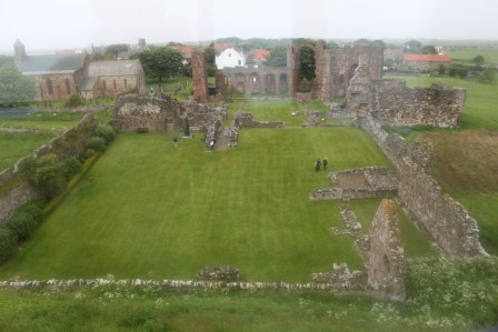
Recently, for the first time in my adult life, I had the opportunity to visit the premier medieval site of Lindisfarne. This is a site of key historic and archaeological importance for understanding the Anglo-Saxon church, its origins, development and diversity. It was here that Aidan established the earliest Christian monastic foundation in the kingdom of Northumbria. His founder status was superseded to a large extent by the cult of St Cuthbert, but forgotten he was not. Lindisfarne is also famous for being subject to one of the earliest, and certainly the most famous of Norse raids, in AD 793. Following a decline (or abandonment) of the site during the tenth century, the Benedictine priory was a focus of monastic life and pilgrimage to the cenotaph of Cuthbert’s original grave and to St Cuthbert’s Isle – the site of his hermit’s cell – through the Middle Ages. The monastery survived until Henry VIII’s suppression of the monasteries.
I couldn’t stay long on the island, but I can only enthuse about the striking landscape and seascape, appreciable even from a short visit. The first thing to note is the striking topography of the island itself, joined as it is by a tidal causeway to the mainland. Dunes constitute much of the north of the island, leaving a relatively small and protected area of habitable ground. The Anglo-Saxon monastery was located beside a natural harbour on the sheltered southern shore.

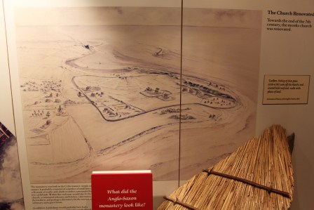
Also framing the monastic complex from sea storms was the rocky spine of higher ground known as the Heugh. The other prominent peak of rock on the island is to the east of the monastic site. Now surmounted by the post-medieval Lindisfarne Castle, the artist’s reconstruction of the Anglo-Saxon monastery in the English Heritage Visitor Centre and the guide book implies some kind of look-out site or fortification may have existing here contemporary with the monastery. St Cuthbert’s Isle, site of the saint’s hermitage, is a further dimension to this distinctive topography and a focus of the historic and modern pilgrim.

I have two points to make. The English Heritage reconstruction of what the monastery looked like focuses on the organisation and appearance of the buildings, with the possibility that the priory churches preserve a linear arrangement of ecclesiastical buildings of Anlgo-Saxon date. However, in my view, the topography of Lindisfarne is the monastery, not only framing ‘the monastery’ but composing it; the island, its shores, harbour and the Heugh and castle sites.

Linked to this observation is the back-projection of the idea of an undefended monastic space only to become subject to defences in the 14th century in response to feared Scottish raids. This cliche is tenacious and underpins the vision of naive monks shocked by the appearance of Viking raiders in 793. Au contraire, I would propose that the Anglo-Saxon site was likely to have begun life as a pairing of monastic and secular elite foci. Perhaps the sites of Lindisfarne Castle and/or the Heugh would have offered a far more than proximal observation points, but also residential spaces discrete from the monastery and key nodes in a defensive system of the island long before the Viking raid of 793. To put it another way, I was inspired to think about whether the monastery was a key maritime central place for the emerging Northumbrian kingdom during the seventh and eighth century. Rather than an exclusively ‘holy’ island, might it have been one dimension of a complex secular complex on the island? To entertain this view should not deny the importance of its pairing with the nearby royal fortress of Bamburgh, but to consider the sacred and secular components of its immediate environs more carefully. I welcome other views on these impressions.


Glad you’ve finally made it there- it’s a wonderful place
I agree about the complexity of the landscape- and I think the regular “pairing” of it with Bamburgh is problematic- apart from anything, Bamburgh clearly had a church of its own (Some of Oswald’s relics were kept there). There has to be a strong possibility that the Beblowe (the castle rock) was the site of a British nuclear thought -was this where Urien besieged his opponents “In insula medcaut” (according to the Historia Britonum)? Of course, whether anything remains of it is the key question – 16th century plans show the crag with a defensive structure on the lesser (eastern) crag, but not the main crag- although I don’t see why something may not survive on the saddle between the two. Interestingly, I’ve recently identified an early medieval carved cross on a boulder on the northern flank of the crag – might be one of the ‘holy places’ on the island that Bede records a miraculously cured boy processing around in his Life of St Cuthbert. This obviously keys into your idea of the complexity of space on the island. There were certainly early medieval secular settlements (at Green Shiel on the north of the island) and seemingly other early medieval activity outside any putative monastic vallum (whether it went along Marygate or Priory Lane). For example, burials have come out from Lewin’s Lane area- this could well be the site of the cemetery of St Columba recorded in medieval charters. Hope-Taylor did excavate on the Heugh but I’ve been looking at his archives and I’m not sure he found any evidence of anything particularly like a secular settlement there.
The wider landscape context is really interesting. As you see it today, the topography is primarily post-medieval- the dune systems are post-med, and med and probably post-med narrow rig extend beyond the current enclosed field systems into the dunes on the northern side of the island. The harbour was also much larger extending further inland making the headland of the village/priory area more pronounced. Also, I don’t think the current causeway was the main access route to the island in the early medieval period. Instead, 18th century maps also show a route running straight out from the main village due west to Fenham. This is important as Fenham was the estate centre for the monastery’s block of estates on the mainland and the centre of the area known as “islandshire” – which intriguingly more or less exactly corresponds to the viewshed from the island itself (except for the Bamburgh itself which pokes out around Ross Point and the hills to the north which lie on the other side of the Tweed.
There is also a wider network of intervisibility around the area- Bamburgh- Farne Islands (from where you can also see St Ebba’s Chapel at Beadnell) and of course on a clear day you can see Yeavering Bell – on an equally clear day (with a following wind) you can also see Coquet Island (which has early med activity) from the Farnes. Coquet Island is also more or less opposite the Anglo-Saxon monastery at Alnmouth.
The wider maritime element of Northumbrian Xiantiy and power more generally is really interesting- all the major monasteries are essentially coastal (or at least on tidal rivers) – Whitby, Hartlepool, Jarrow, Wearmouth, Tynemouth, Alnmouth, Holy Island, Coldingham, St Abb’s etc etc (why is there nothing on the Tweed at Berwick..?). There is a similar fascinating nexus of secular/ecclesiastical power a little further north around Dunbar/Auldhame/Tyningham – with some pretty interesting, if slightly earlier, things going on at Traprain Law and Broxmouth. I burbled about this in a short paper in Estonian Journal of Archaeology (obviously…) http://www.kirj.ee/16488/?tpl=1061&c_tpl=1064